


Greenway’s overall goal is to link the communities of the Village of Canal Flats, BC to Donald, BC (west of Golden, BC) by a trail network (The Upper Columbia Trail Network) for non-motorized forms of transport. The trail system begins with a ‘spine trail’ which will form a primary route which will extend along the length of the Columbia Valley. The spine trail will serve to connect current trails with new routes where required to provide a safe transportation corridor for Columbia Valley Residents and visitors. The trail network will also provide greenways corridors that will link existing nodes of ecological significance as well as connecting and highlighting regions of cultural and historical importance.
Map of The Upper Columbia Trail Network – Proposed
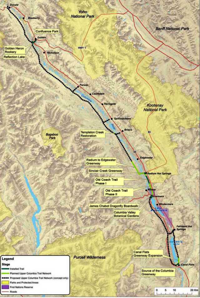
In working towards the completion of the Upper Columbia Trail Network, Greenways currently has several projects and project phases completed and underway throughout the Columbia Valley.
Current Trail Initiatives
Each trail section typically consists of multiple phases which are in various stages of development. Collectively, these individual projects will move Greenways closer to achieving it’s large scale vision of linking the entire Upper Columbia River Valley from the Village of Canal Flats, to Donald, BC (west of Golden, BC).
Phase I
- Old Coach Road (Radium to Dry Gulch Link)
Phase II & III (Dry Gulch to Invermere/ Crossroads Link)
- Dry Gulch to Kinbasket South boundary
- Kinbasket lands boundary to Invermere/ Crossroads
2) Fairmont to Crossroads Link
- Section A – Top of Athalmer Road hill to Athalmer Rd & Hwy 93/95 Junction (1 km).
- Section B – South of Athalmer Rd. along Lakeview Dr., south of the cemetery parking lot, the trail continues eastward towards the Columbia Valley Chamber of Commerce office (1.5 km)
- Section C – South of the cemetery parking lot turn off (for Section B) along Lakeview Dr., eastward along Timberview Drive, north through the Copper Point Golf Course, ending at the Columbia Valley Chamber of Commerce office.
4) Existing Trail Restoration
- Templeton Creek
Completed Trail Initiatives
Greenways has been instrumental in the completion of many trails throughout the Upper Columbia River Valley. These achievements would not have been possible without the help of landowners, partners, and community members who have provided continued support to various Greenways projects presently underway.
Upon the completion of the Upper Columbia Trail network, the below trails will be connected to the main ‘spine trail’, which will link the entire Upper Columbia River Valley from the Village of Canal Flats, to Donald, BC.
Golden Area
Radium Area
Invermere Area
- Dragonfly Boardwalk (James Chabot/ Athalmer Beach)
- CVBG Garden & Greenhouse Trails
- Old Coach Trail
Columbia Lake Area